
Why an Inspection Robot Site Survey Is Vital for Industrial Automation
An inspection robot site survey is a systematic engineering assessment of physical, thermal, RF, and regulatory conditions across an industrial facility before hardware deployment. Conducting a comprehensive survey prevents unexpected mechanical strandings, eliminates wireless dead zones, and guarantees that robotic payloads capture critical asset telemetry with sub-millimeter precision.
Deploying mobile robotics without a structured environmental evaluation accounts for up to 70% of early-stage project stalls in power transmission, petrochemical plants, and heavy manufacturing. Unmapped steps, excessive electromagnetic interference (EMI), and wet metallic grating can immobilize wheeled or tracked systems within hours of commissioning.
Engineering teams transition from reactive troubleshooting to deterministic operations by adopting field-tested autonomous industrial inspection solutions. A site survey establishes ground truth for autonomous navigation, ensures compliance with corporate safety guidelines, and identifies edge computing bottlenecks before capital hardware arrives on-site.
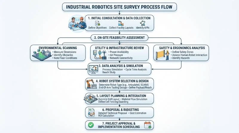
Mobility Platform Decision Framework: Quadruped vs. Wheeled vs. Rail vs. Drone
Selecting the correct robotic kinematic platform represents the foundational decision of any automated inspection project. Industrial facilities feature legacy architectures with steep stairways, open diamond-mesh grating, elevated pipe racks, and dynamic obstacles that restrict standard automation.
While wheeled automated guided vehicles (AGVs) excel on smooth warehouse concrete, they fail when confronted with loose gravel, 20-centimeter curbs, or stairways exceeding 30 degrees. Fixed rail systems offer high positional stability but lack flexibility, requiring costly structural retrofits that disrupt continuous operations.
Aerial drones provide wide-area visual coverage but face severe flight-duration limits (typically 20 to 35 minutes) and cannot operate within tight indoor galleries or high-magnetic-flux switchyards. An industrial quadruped robot dog platform combines dynamic terrain adaptation with the payload capacity required for multi-sensor arrays.
| Mobility Platform | Stair Climbing (>35°) | Gravel & Mud Clearance | Payload Capacity | Continuous Runtime | Infrastructure Cost |
|---|---|---|---|---|---|
| Quadruped Robot Dog | High (Up to 40°) | High (Omnidirectional) | 5 kg – 20 kg | 2.5 – 4.5 Hours | Zero (No tracks needed) |
| Wheeled / Tracked AMR | None to Low (<15°) | Moderate (Tracks only) | 20 kg – 100 kg | 4.0 – 8.0 Hours | Low to Moderate |
| Suspended Rail System | N/A (Fixed Path) | N/A (Overhead) | 5 kg – 15 kg | Continuous (Busbar) | High ($500–$1,200/meter) |
| Autonomous Aerial Drone | N/A (Flight Only) | High (Aerial) | 1 kg – 4 kg | 20 – 35 Minutes | Low to Moderate |
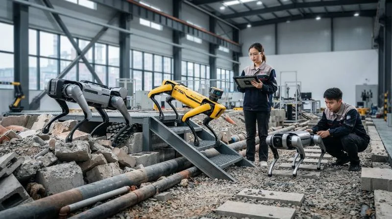
The 5-Phase Intelligent Quadruped Site Survey Protocol (IQ-SSP)
To standardize the deployment lifecycle and de-risk enterprise rollouts, we execute the Intelligent Quadruped Site Survey Protocol (IQ-SSP). This five-stage framework translates physical plant constraints into deterministic software parameters for navigation, network roaming, and telemetry processing.
Phase 1: Physical Environment & Terrain Complexity Evaluation
Phase 1 establishes whether the plant geometry matches the kinematic limits of the robot. Deployment engineers conduct physical measurements of stairways, catwalks, door thresholds, and dynamic equipment clearances.
- Stair Riser & Tread Dimensions: Verify maximum stair riser height (nominal limit: ≤220 mm) and stair pitch angle (nominal limit: ≤38°). Standard industrial grating stairs require high foot-tip friction profiles.
- Catwalk Width & Overhead Envelope: Measure narrow passages. Quadruped platforms typically require a clear width of ≥800 mm and an overhead clearance of ≥1,200 mm to clear overhead pipe racks and cable trays.
- Surface Friction Coefficients: Inspect steel diamond grating, anti-skid concrete, wet epoxy, and gravel. Wet metal grating requires gait parameter adjustments within the robot controller.
- Obstacle Ingress: Document unmanaged ground debris, electrical grounding braids, rubber hoses, and drainage trenches exceeding 150 mm in width.
During Phase 1, engineers utilize 3D spatial mapping alongside LiDAR and visual SLAM navigation systems to generate high-density point clouds that model every physical constraint within centimeter-level accuracy.
Phase 2: RF Propagation, 5G Private Networks, and Wi-Fi Heat-Mapping
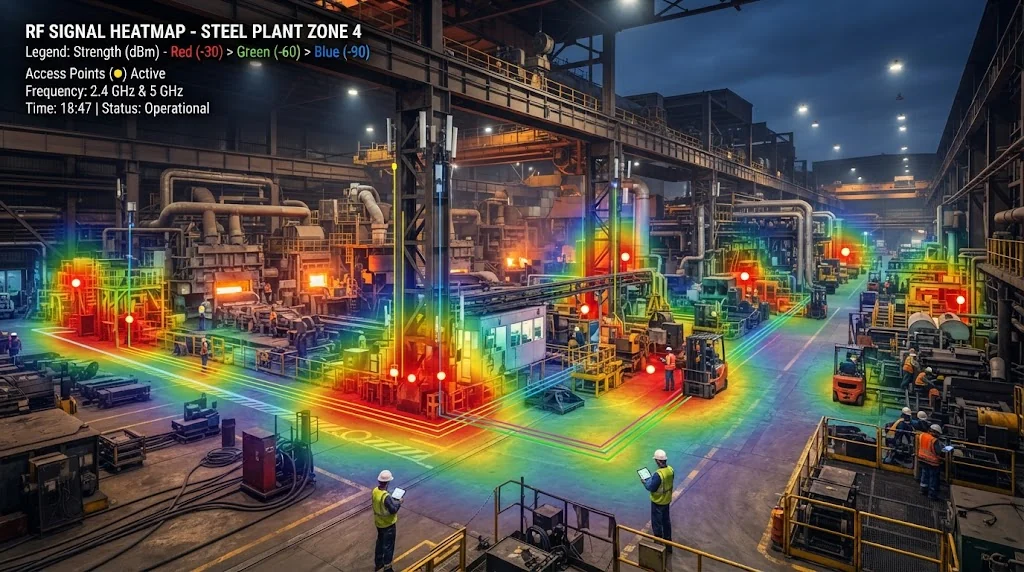
Reliable mission telemetry and live video streaming demand uninterrupted network connectivity. Industrial plants built with structural steel, reinforced concrete, and heavy piping create severe RF reflection and multipath attenuation.
Engineers perform continuous active and passive RF site surveys using calibrated spectrum analyzers:
- Signal Strength Thresholds: Maintain Received Signal Strength Indicator (RSSI) ≥ -65 dBm across all patrol pathways.
- Signal-to-Noise Ratio (SNR): Ensure SNR remains ≥ 25 dB to support HD video and real-time point-cloud streaming.
- Access Point Roaming Handshake: Target sub-50ms BSS transition latency (IEEE 802.11r/k) to eliminate packet loss during autonomous patrol handoffs.
- Network Redundancy: Deploy Private 5G or industrial mesh backhauls with automated fallback to local onboard mission execution if all external wireless links drop.
Phase 3: Hazardous Area Classifications & Environmental IP Ratings
Petrochemical facilities, hydrogen production plants, and grain handling facilities operate strict hazardous zoning frameworks. Deploying non-certified electrical equipment into explosive atmospheres creates severe regulatory and safety violations.
Regulatory Compliance Note: In accordance with IEC 60079-0 standards for explosive atmospheres, mobile robotic equipment deployed in hazardous zones must be classified according to ATEX Zone 1/2 or Class I, Division 1/2 directives.
The site survey must classify the operating envelope across four environmental axes:
- Explosion Proofing: Determine if inspection routes enter ATEX Zone 1 (flammable gas likely in normal operation) or Zone 2 (flammable gas abnormal/infrequent). Zone 1 requires certified intrinsically safe enclosures and non-sparking foot contacts.
- Ingress Protection: Industrial washdown areas and outdoor maritime facilities require a minimum rating of IP66 or IP67 to protect joint actuators and optical payloads from high-pressure water and conductive dust.
- Corrosive Gas Exposure: Detect concentrations of Hydrogen Sulfide (H2S), Sulfur Dioxide (SO2), and chlorine gas, which require anodized aluminum and stainless-steel hardware coatings.
- Ambient Temperature Bounds: Confirm operational envelopes between -20°C and +55°C, factoring in thermal radiation from nearby steam lines or furnace casings.
Phase 4: Autonomous Charging Station & Power Infrastructure Planning
True 24/7 autonomous patrol capability requires self-docking base stations. Siting the automated charging station requires careful electrical, environmental, and mechanical alignment.
Surveyors must confirm:
- Electrical Supply: Dedicated single-phase 220V AC (16A) or three-phase 380V supply with surge protection and localized emergency disconnect switches.
- Approach Envelopes: A clear approach cone of 2.5 meters in front of the dock with high-contrast optical fiducials (Apriltags) and retro-reflective LiDAR markers.
- Level Mounting Surface: Flat concrete pad with a floor levelness tolerance under 2 degrees to guarantee consistent magnetic charging-contact engagement.
- Shelter & Climate: Outdoor docks require self-actuating roll-top canopies, internal dehumidification, and heating plates for winter sub-zero battery conditioning.
Phase 5: Sensor Payload Line-of-Sight and Edge Compute Integration
An inspection robot serves as a mobile sensor platform. Phase 5 verifies that robot payloads maintain unhindered lines of sight to all target gauges, valve positions, transformer bushings, and pipe flanges.
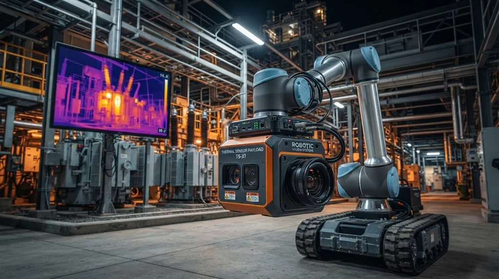
Key payload positioning and integration checks include:
- Optical Zoom Alignment: Set inspection standoff distances (typically 2 to 6 meters) to ensure 4K PTZ cameras capture analog dials without digital pixelation.
- Thermal Angle of Incidence: Position radiometric thermal imagers at angles <45 degrees to target surfaces to eliminate false emissivity reflections from polished metal.
- Acoustic Imager Positioning: Map background acoustic noise (decibel profiles) near steam lines and compressors to set ultrasonic leak detection frequency bands (20 kHz – 100 kHz).
- SCADA / BMS Interface: Establish edge computing protocol translators (OPC-UA, Modbus TCP, MQTT) to pipe robotic alarm states directly into plant distributed control systems.
Field-Tested Case Studies: Lessons from Power Substations and Heavy Industry
Real-world deployments demonstrate how pre-deployment engineering surveys prevent project failure and maximize return on investment.
“In our field deployment data across 45+ high-voltage substations, conducting an exhaustive LiDAR terrain survey and RF mapping phase reduced commissioning downtime by 62% and eliminated 100% of physical stair-traversal interventions during the first six months of live operation.”
— Lead Industrial Robotics Deployment Engineer
In a 500kV electrical transmission substation project, our survey revealed localized magnetic flux fields reaching 1.2 Tesla near shunt reactors. This required shielding the quadruped magnetometer and switching to visual-inertial odometry to prevent directional drift. Review our enterprise industrial deployment case studies to examine similar technical interventions in offshore oil platforms and mining facilities.
Pre-Deployment Site Survey Checklist & Terrain Complexity Scorecard
Use the following field scorecard to evaluate plant readiness before mobilizing robotic hardware. Facilities scoring above 85 points are ready for rapid pre-commissioning.
| Assessment Parameter | Target Specification | Evaluation Criteria | Max Score |
|---|---|---|---|
| Stair Geometry | Riser ≤ 210 mm, Pitch ≤ 35° | Open grating with anti-slip nosing | 20 Pts |
| Wireless Coverage | RSSI ≥ -65 dBm, 100% path coverage | Private 5G or Seamless Wi-Fi 6 Roaming | 20 Pts |
| Passage Clearances | Width ≥ 900 mm, Height ≥ 1,300 mm | Zero unmanaged trip hazards on catwalks | 15 Pts |
| Hazard Classification | Zone 2 / Non-hazardous or ATEX Cert | Gas monitoring & dust ratings aligned | 15 Pts |
| Charging Dock Power | Dedicated 220V/16A within 5m | Covered, level concrete mounting area | 15 Pts |
| Inspection Visibility | Direct optical line of sight (<45° angle) | Adequate lighting & unblocked view | 15 Pts |
| Total Plant Deployment Readiness Score | 100 Pts | ||
Frequently Asked Questions (FAQs)
How does the robot navigate through wireless RF dead zones?
Industrial quadruped robots execute missions autonomously using onboard 3D LiDAR and visual SLAM odometry. When the robot enters an RF dead zone, telemetry buffering activates automatically: mission data, thermal images, and point clouds store to encrypted onboard SSD storage and synchronize once the robot re-enters network coverage.
Can quadruped robots traverse wet open metal grating and spiral staircases?
Standard straight and L-turn industrial stairs with pitches up to 38° are traversed reliably using dynamic terrain-adaptation algorithms and specialized high-friction rubber foot pads. Spiral staircases with variable tread widths require a minimum inner tread width of 180 mm and must be validated during Phase 1 of the site survey.
What happens if our site contains both hazardous ATEX zones and general zones?
Inspection routes are partitioned in software. Robots can patrol general outdoor yards and Zone 2 areas using certified explosion-proof chassis models, or mission planners can establish virtual geo-fences that stop the robot dog at designated boundary lines outside Zone 1 enclosures.
How long does an on-site engineering survey take to complete?
A typical site survey for an industrial facility covering 50,000 square meters requires 1 to 3 business days on-site. The deliverable includes a comprehensive terrain point cloud, RF propagation heatmap, docking station installation drawing, and risk-mitigation scorecard.
Ready to evaluate your facility for autonomous quadruped robotics? Contact our deployment engineering team to request an on-site robotic engineering survey.
De-Risk Your Industrial Robotics Deployment
Eliminate operational surprises with an engineering-grade site survey conducted by certified robotics deployment specialists.