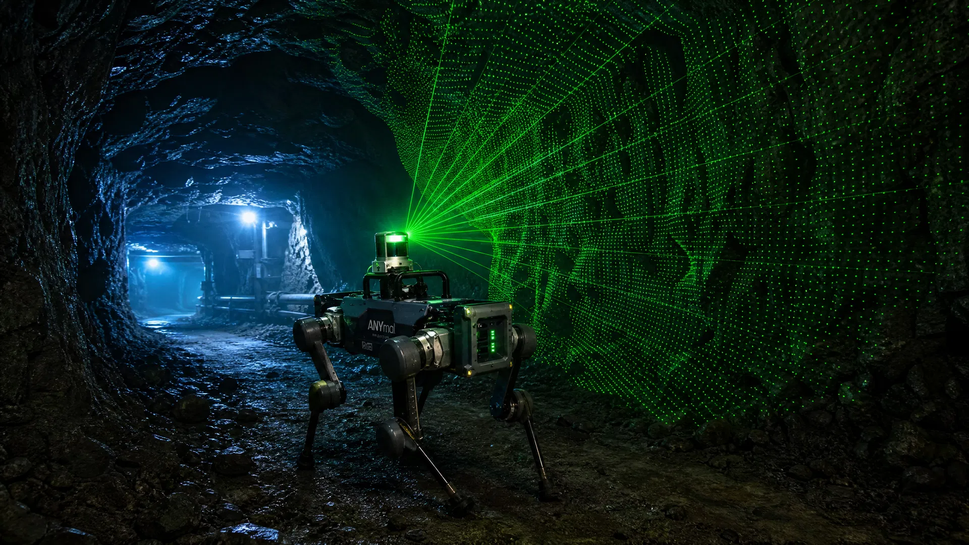
Ask most people how a robot knows where it is, and they’ll say GPS. It’s a reasonable assumption — GPS is how everything from delivery trucks to smartphones navigates. But GPS depends on signals from satellites, and those signals don’t penetrate buildings, don’t reach underground, and get severely degraded in dense urban canyons or near large metal structures. For industrial inspection robots, which spend most of their working lives inside facilities, underground, or in signal-attenuated environments, GPS is simply not available.
🔗 Related Products & Resources
- RZTL-1 NavKit — Enhanced SLAM navigation package for GPS-denied environments
- SLAM Navigation Technology — LiDAR-inertial odometry deep dive
- Mining Inspection Solution — Underground coal mine gas monitoring
- Case Study: Underground Coal Mine — Real-world SLAM in 2.4 km tunnel network
This creates a navigation challenge that’s more technically interesting than it might appear. A robot that can’t localize itself can’t navigate reliably, can’t repeat inspection routes, and can’t build the consistent spatial data that makes trend analysis possible. Solving GPS-denied navigation is, in many ways, the core technical challenge of industrial inspection robotics.
This article explains how modern inspection robots solve that challenge, what the different approaches mean for operational performance, and what facility operators should understand when evaluating platforms for GPS-denied environments.
The Navigation Problem in Industrial Facilities
Industrial facilities present a particularly demanding navigation environment. They’re large — a major power plant or petrochemical facility might cover hundreds of thousands of square meters. They’re structurally complex, with equipment, piping, cable trays, and structural steel creating a three-dimensional obstacle environment. They change over time as equipment is installed, moved, or removed. And they’re often partially or fully enclosed, eliminating GPS entirely.
Underground environments add additional challenges: mining operations, metro tunnels, utility tunnels, and underground storage facilities often have limited communication infrastructure, poor lighting, and irregular terrain that makes navigation even more demanding.
For a human inspector, none of this is particularly challenging — people are remarkably good at navigating complex environments using a combination of visual landmarks, spatial memory, and intuition. Replicating that capability in a robot requires a fundamentally different approach.
SLAM: The Foundation of GPS-Free Navigation
The dominant approach to GPS-denied navigation in modern inspection robots is SLAM — Simultaneous Localization and Mapping. The name describes exactly what the algorithm does: it builds a map of the environment while simultaneously figuring out where the robot is within that map. These two problems are deeply interdependent (you need a map to localize, and you need to know your location to build an accurate map), which is what makes SLAM technically challenging and why it took decades of research to make it practically useful.
Modern SLAM implementations use several sensor modalities:
LiDAR-Based SLAM
LiDAR (Light Detection and Ranging) sensors emit laser pulses and measure the time of flight to calculate distances to surrounding surfaces. A rotating LiDAR generates a dense 3D point cloud of the environment — essentially a precise geometric model of everything the sensor can see. LiDAR-based SLAM uses this point cloud data to build and maintain a map, and to localize the robot within that map by matching current sensor readings against the stored map.
LiDAR SLAM is highly accurate and works well in the structured environments typical of industrial facilities. It’s relatively insensitive to lighting conditions — LiDAR works equally well in complete darkness and bright sunlight. The main limitation is that LiDAR can struggle in environments with highly repetitive geometry (long corridors with identical features) where the matching algorithm may produce ambiguous results.
Visual SLAM
Visual SLAM uses cameras instead of LiDAR, applying computer vision algorithms to identify visual features in the environment and track how they move as the robot moves. This allows the algorithm to infer the robot’s motion and build a map from visual observations.
Visual SLAM is computationally intensive but can work with relatively inexpensive camera hardware. It’s sensitive to lighting conditions and can struggle in low-light environments or in areas with few distinctive visual features. Many modern inspection robots use visual SLAM in combination with LiDAR — using LiDAR for structural mapping and cameras for feature-rich environments where visual landmarks provide additional localization accuracy.
IMU Integration
Inertial Measurement Units (IMUs) measure acceleration and angular velocity, allowing the robot to track its own motion between sensor updates. IMU data is integrated with SLAM to provide smooth, continuous localization even when sensor updates are infrequent. IMUs are particularly important for quadruped robots, where the complex leg motion creates significant vibration that must be filtered out of the navigation solution.
How Modern Robots Handle Challenging Navigation Scenarios
Understanding the theory of SLAM is useful, but what facility operators actually care about is how robots handle the specific navigation challenges they’ll encounter in real deployments.
Long, Featureless Corridors
Utility tunnels, mine access drifts, and equipment corridors often present long stretches of nearly identical geometry — the classic “perceptual aliasing” problem for SLAM. The robot’s sensor data looks the same at multiple points along the corridor, making it difficult to determine exact position.
Modern platforms address this through several mechanisms: using multiple sensor modalities to increase the distinctiveness of environmental observations, incorporating artificial landmarks (fiducial markers or RFID tags) at strategic locations, and using wheel odometry or leg kinematics to maintain position estimates between distinctive features.
Dynamic Environments
Working industrial facilities are not static. People move through them, equipment gets repositioned, temporary structures appear and disappear. A SLAM system that treats every change as a map update will quickly accumulate errors; one that treats the environment as completely static will fail when obstacles appear.
Robust SLAM implementations distinguish between static structural features (walls, fixed equipment, structural steel) and dynamic objects (people, vehicles, temporary obstacles). Static features are used for localization; dynamic objects are detected and avoided without being incorporated into the map.
Underground and Subterranean Environments
Underground environments present the most demanding navigation conditions: irregular terrain, limited communication infrastructure, potential for dust or water that degrades sensor performance, and the absence of any external reference signals. Research published in 2025 and 2026 has demonstrated quadruped robots navigating underground mine environments autonomously, using LiDAR SLAM combined with terrain-adaptive locomotion to handle the irregular surfaces typical of mining environments.
The key technical requirement for underground deployment is that the robot’s navigation must be entirely self-contained — it cannot rely on any external infrastructure for localization. This places high demands on the quality of the onboard SLAM implementation and the robot’s ability to recover from localization failures.
Multi-Floor and Vertical Navigation
Many industrial facilities have multiple levels connected by stairs, ramps, or elevators. Navigation across floors requires the robot to maintain a consistent coordinate system across level transitions — a non-trivial problem for SLAM systems that build 2D floor maps. Platforms designed for multi-floor facilities typically maintain 3D maps and use level transitions as known landmarks for localization.
Communication in Signal-Attenuated Environments
Navigation and communication are related but distinct problems. A robot can navigate autonomously without any communication link, but operators need to monitor robot status, receive inspection data, and intervene if problems occur. In GPS-denied environments, communication infrastructure is often as limited as positioning infrastructure.
Several approaches are used for communication in challenging environments:
Mesh radio networks: Multiple radio nodes deployed throughout the facility create a mesh network that provides coverage even in areas where direct line-of-sight to a base station is unavailable. The robot communicates with the nearest mesh node, which relays data back to the control system.
Leaky feeder cables: Widely used in mining and tunnel environments, leaky feeder cables are coaxial cables with slots cut in the outer conductor that allow radio signals to “leak” out along the cable’s length. This provides continuous communication coverage along the cable route.
Store-and-forward operation: For environments where real-time communication is not possible, robots can operate in a store-and-forward mode — collecting inspection data autonomously and uploading it when they return to a communication-accessible area. This requires more sophisticated onboard autonomy but eliminates the communication infrastructure requirement.
What This Means for Facility Operators
For operators evaluating inspection robots for GPS-denied environments, the navigation question deserves more attention than it typically receives in vendor evaluations. A few practical considerations:
Validate navigation performance in your actual environment. SLAM performance is highly environment-dependent. A robot that navigates reliably in one facility may struggle in another with different geometry, surface materials, or dynamic characteristics. Request a pilot deployment in a representative section of your facility before committing to a full deployment.
Understand the map update process. Your facility will change over time. How does the robot update its map to reflect those changes, and how much operator effort does this require? Platforms that require complete remapping after significant facility changes create ongoing operational overhead.
Ask about failure modes and recovery. What happens when the robot loses localization? Does it stop safely and alert the operator, or does it continue operating in a degraded mode that might create safety risks? How quickly can it recover, and what operator intervention is required?
Consider communication infrastructure requirements. If you need real-time monitoring of robot status and inspection data, understand what communication infrastructure the platform requires and what it will cost to deploy in your facility.
The State of the Technology
GPS-denied navigation for inspection robots has advanced dramatically in the past five years. Platforms that would have struggled to navigate a complex industrial facility reliably in 2020 can now do so routinely. The research community has made significant progress on the fundamental SLAM algorithms, and commercial platforms have benefited from that progress.
That said, GPS-denied navigation remains an active area of development, and performance varies significantly between platforms. The best commercial systems can navigate complex, dynamic, GPS-denied environments with high reliability — but “high reliability” is not the same as “perfect reliability.” Operators should plan for occasional navigation failures and ensure that their deployment includes appropriate monitoring and intervention procedures.
For underground and subterranean environments specifically, the technology is advancing rapidly. Academic research published in 2025-2026 demonstrates quadruped robots navigating underground mine environments with increasing autonomy and reliability. Commercial deployment in these environments is still relatively early-stage, but the trajectory is clear.
Conclusion
GPS-denied navigation is a solved problem for most industrial inspection applications — not perfectly solved, but solved well enough for reliable operational deployment. Modern SLAM-based navigation systems allow inspection robots to operate autonomously in the complex, dynamic, GPS-denied environments that characterize real industrial facilities.
Understanding how these systems work helps facility operators ask better questions during platform evaluation, set appropriate expectations for operational performance, and design deployment configurations that maximize reliability. The navigation question is worth the time it takes to understand properly — it’s the foundation that everything else in an inspection robot deployment is built on.
Tagged: